Project History

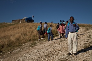
The youngest son of Mme. Maurice (featured in the previous post), is the principle of this school in Mourne Mouton, one of the first schools me and Will mapped during our time in Haiti last spring.
Haiti is the one of the most impoverished countries in the western hemisphere, and Haiti’s people suffer the highest rates of malnutrition, infant mortality, and maternal mortality in the Americas. Malnutrition functions as a root cause of other health concerns; thus, any long-term strategies to improve health must address the issues underlying food insecurity. Malnutrition is especially acute in the Central Plateau region, where a history of dam building, deforestation and erosion has left families farming dry and impoverished upland soils. Partners in Agriculture (Zamni Agrikol – ZA), a sister organization of Partners in Health (Zamni Lasante – ZL), aims to combat malnutrition over the long term and improve livelihoods in the Central Plateau by working with families to raise agricultural productivity. Currently, ZA has some 2,000 participants in a highly successful Family Assistance Program (FAP), in which households are given seeds, tools, technical assistance and a few trees.
Beginning in 2006, Sewanee students and faculty have traveled to Cange to learn how poverty, environmental degradation and poor health are interconnected, and to witness how organizations such as Partners in Health (Zamni Lasante) and Partners in Agriculture (Zamni Agrikol) are systemically improving public health and food security in the Central Plateau. The beginnings of this project originated with the hard work of Sean McKenzie (class of 2011), who in addition to inhabiting on a semi permanent basis Sewanee’s Landscape Analysis Lab, gallivanting into the night to witness the marvels of salamander spawning in Sewanee’s ephemeral ponds, and dazzling everyone with his skills in ecology and GIS, traveled to Zamni Lasante in Cange for the summer of 2010 in order to map ZL schools and the zones of the ZA Family Assistance Program. Unfortunately Sean’s summer break happened to coincide with Haiti’s rainy season, and at the end of the summer the maps were not quite complete.
In order to complete the maps, Dr. McGrath, Will Watson, and I traveled to Cange in the Spring of 2012. In addition to continuing Sean’s work on the mapping project, we had the opportunity to witness a team of Clemson engineers installing a water pump to increase the supply of water to Cange, to hike across the Haitian hillside with ZA agronoms, and to begin the discussion about a PES project in Cange. Because the potential activities that would produce carbon credits are activities that ZA is already implementing or hoping to implement in the future through the Family Assistance Program, we hope that the local support and organizational structures for setting such a project in motion are well underway. The question now is whether the sale of carbon credits will be profitable enough to allow ZA to implement new activities, and scale up cabon sequestering activities that are already underway.
Check out our Schools map so far!